Mount Kitumbeine Climbing Guide
mount kitumbeine overview
kitumbeine at a glance (quick facts)
what is mount kitumbeine famous for?
where is mount kitumbeine located?
why should i climb mount kitumbeine?
what wildlife can i see on kitumbeine?
when is the best time to climb kitumbeine?
is kitumbeine good for first-time climbers?
is mount kitumbeine safe to climb?
how many days do i need for kitumbeine?
what activities are available around kitumbeine?
where do i stay for a kitumbeine climb?
is kitumbeine suitable for families?
what should i pack for mount kitumbeine?
how much does a kitumbeine climb cost?
how do i get to mount kitumbeine?
can kitumbeine be combined with other trips?
kitumbeine vs longido vs lengai?
why book kitumbeine with safari-tz.com?
Mount Kitumbeine Overview
An Expedition Climb in Empty Maasai Country recount:
Mount Kitumbeine overview from Safari-tz.com: a rarely climbed volcano between Longido and Lake Natron, arranged expedition-style with local guides.
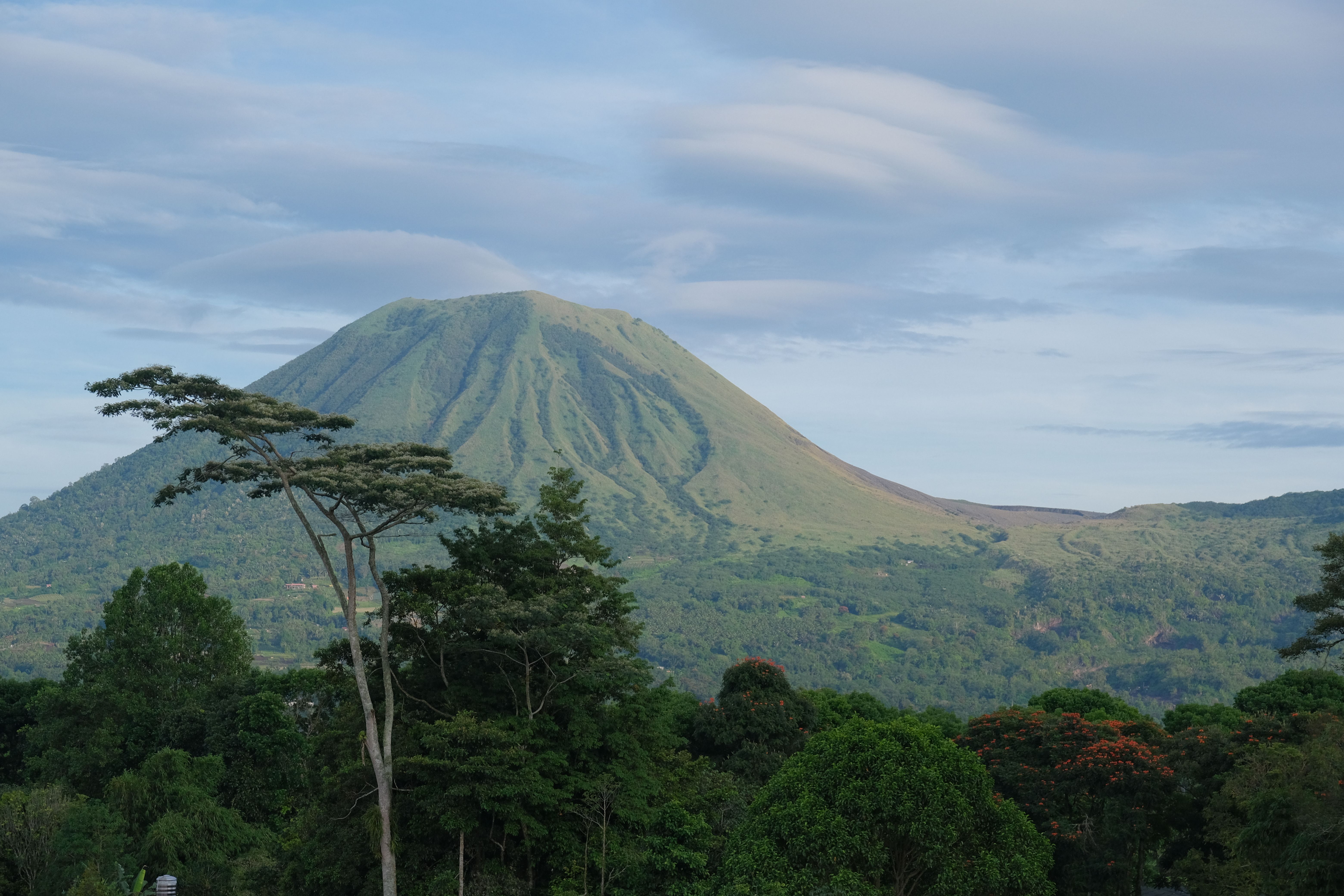
Mount Kitumbeine stands in the dry Maasai country south of the Kenya border, a broad volcano rising past 2,800 metres between two mountains this website has already climbed: Longido to its east, Ol Doinyo Lengai off to its west toward Lake Natron. Unlike either neighbour, Kitumbeine has no climbing tradition to speak of. No programme, no trail signs, no gate, no schedule. What it has is a mountain, villages at its base, Maasai guides who know its paths as grazing routes, and a summit forest that turns the top of a dust-country volcano improbably green.
That forest is the mountain's signature. Kitumbeine's height traps enough moisture to grow real montane forest on its upper reaches, a green island floating over brown plains, protected as a forest reserve and used, by local account, by more wildlife than a first glance at the surrounding country would ever suggest.
Be clear about what buying this climb means, because the page will keep saying it: this is an arranged expedition, not a product off a shelf. We build Kitumbeine climbs case by case, on request, with local arrangements confirmed for your specific dates, camping logistics carried in, and an itinerary that treats uncertainty as part of the design.
For the traveller that description excites rather than worries, Kitumbeine is the most interesting unclaimed summit in northern Tanzania.
Kitumbeine at a Glance (Quick Facts)
Key Facts Before You Ask About Kitumbeine
Quick Mount Kitumbeine facts from Safari-tz.com: a 2,800-metre-plus Rift volcano, summit forest, no tourism structure and on-request expeditions.
The short version: a big, rarely climbed Rift volcano with a forested summit, no tourism infrastructure whatsoever, and climbs built expedition-style on request.
-Height: Past 2,800 metres, taller than Longido, shorter than Hanang, and wilder than both by a distance.
-The signature: A montane forest crowning the summit zone, a green island over dry plains, protected as a forest reserve.
-Status: No park, no programme, no gate. Village and reserve arrangements made case by case through local contacts.
-Format: Realistically two days with a camp, occasionally one very long day for strong parties. Confirmed per expedition.
-Guides: Local Maasai guides from the villages at the mountain's base, engaged per climb. They know the mountain as working country.
-Wildlife note: Local accounts put buffalo and other large animals in the summit forest and slopes. The guides' routing respects it, and so do we.
-Access: Rough 4x4 tracks off the Longido and Natron-road sides. The approach is part of the expedition.
-Best months: June to October, then December to February. Dry country, dry logic.
-Fitness: Strong, with expedition temperament. This page's first-timer section says no, and means it.
-Crowds: The concept does not apply here.
What Is Mount Kitumbeine Famous For?
A Green Summit Nobody Comes to Collect
Mount Kitumbeine is known, barely, for its improbable summit forest, its emptiness between Longido and Lengai, and climbs that feel like first ascents.
Famous is the wrong word, and that is the honest starting point: Kitumbeine is known to geologists, to conservationists, to the Maasai who live on it, and to a very short list of climbers, in roughly that order. What each group knows sketches the mountain.
The geologists know it as one of the big volcanoes of the Natron rift country, part of the same volcanic family as Gelai to its north and Lengai beyond, the landscape's older, quieter generation against Lengai's live wire. The conservationists know the summit forest: a genuine montane forest reserve stranded on top of a dry-country volcano, valuable precisely because such green islands are rare, and connected by local account to wildlife movement through this whole stretch of Maasailand. The Maasai know it as home ground, grazing country, a mountain woven into the working life of the villages at its base, and their paths are the only trails it has.
The climbers, the few, know the feeling the other three facts add up to: an ascent that plays like exploration. No signage, no other parties, a route read by guides rather than followed by feet, plains opening below as you climb, and a summit forest arrival that no photograph from the bottom prepares you for. Guests who have done the famous mountains use a specific word for Kitumbeine afterwards, and the word is "expedition." This page uses it the same way, deliberately, throughout.
Where Is Mount Kitumbeine Located?
Finding Kitumbeine on the Tanzania Map
Mount Kitumbeine rises in Longido district's Maasai plains, south-west of Longido mountain and east of the Lake Natron and Lengai country.
Kitumbeine occupies the empty middle of a triangle every northern traveller brushes past: Longido mountain and its Namanga road to the east, the Lake Natron and Lengai country to the west, and Arusha's orbit to the south. The volcano rises alone from the plains of Longido district, big enough to organise the horizon for an hour of driving in any direction, and positioned in country that the main roads frame without entering.
That framing is the access story in miniature. There is no tarmac to Kitumbeine and no schedule of anything; the approaches run on rough 4x4 tracks, from the Longido and Namanga-road side or from the west where the Engaruka–Natron routing passes through the same district, and both approaches are covered properly in the access section below. What matters at the map stage is the implication: Kitumbeine sits a half-day of hard track from roads this website has already sent you down, for Longido's climb on one side and Lengai's on the other, which is exactly why the combinations section can do something unusual with it.
The mountain's own geography explains its character twice over. Its bulk catches the moisture that the plains never see, which built the summit forest; and its position in working Maasailand, villages, bomas, stock routes threading its lower slopes, means the human geography is pastoral, unbrokered, and entirely uninterested in tourism, which is both the logistical challenge and the entire appeal.
Why Should I Climb Mount Kitumbeine?
The Case for the Map's Last Blank Spot
Why climb Kitumbeine: expedition-grade solitude, a summit forest over dry plains, unbrokered Maasai country and a climb that plays like exploration
Because everything else on this website, however quiet, is a known quantity, and Kitumbeine is the one climb we sell where the map still feels like it has edges.
The solitude here needs a new unit of measurement. Longido runs quiet, Hanang runs empty, and Kitumbeine runs absent: the mountain has no climbing traffic to be quieter than, and a party on its slopes is an event the villages will discuss. For the small tribe of travellers who collect that specific feeling, walking in country that has not arranged itself for you, no other summit within a day of Arusha comes close.
The summit forest is the sensory argument. You climb out of dust, thorn and herding country, hours of it, and arrive in green shade with a canopy overhead, a transition so abrupt that guests describe it as changing countries mid-mountain. The forest island over brown plains is Kitumbeine's photograph, and unlike this cluster's haze-governed horizon views, it cannot be weathered away.
The cultural texture closes the case, stated carefully. This is unbrokered Maasailand: no programme, no rehearsed visit, just the working pastoral world your route necessarily passes through, hosted by guides who belong to it. The encounters are real because nothing about them was designed, and our respect rules, always the guides' lead, everything on the hosts' terms, carry more weight here than anywhere we operate, precisely because no structure exists to carry them for us.
What Wildlife Can I See on Kitumbeine?
A Forest With Residents, Honestly Framed
Kitumbeine wildlife is real but unstudied by tourism: local accounts put buffalo and large game in the summit forest, and guide routing respects it.
This section is written more carefully than any wildlife section on this website, because Kitumbeine's wildlife is real, consequential, and almost entirely undocumented by the tourism industry, which means honest framing matters twice.
What we can say with confidence: the summit forest and upper slopes are genuinely wild habitat, the local accounts our guides work from put buffalo in that forest as residents rather than rumours, and larger animals, elephant included, are reported to move through this stretch of Maasailand and its green mountains. What we refuse to say: any sighting promise whatsoever. This is not a game-viewing product, no habituation exists, no density figures exist, and a Kitumbeine climb should be bought expecting to see herds, birds of the dry country, and possibly nothing wilder than fresh sign.
The safety dimension follows directly and gets its full treatment in the safety section: forest with buffalo in it is walked on the guides' terms, their reading of sign and their routing decisions final, and this is among the strongest practical reasons the expedition format exists. Travellers should understand that the wildlife here shapes the climb without performing for it.
The reliable register, as everywhere in this dry-mountain family, is the modest one: raptors working the volcano's thermals, dryland birdlife for carried binoculars, small game possible, and the Maasai herds below doing what they have always done. The redirect stands at cluster strength: safari-scale certainty lives in the parks, one road east.
When Is the Best Time to Climb Kitumbeine?
Kitumbeine Seasons, Honestly Told
Climb Kitumbeine from June to October or December to February. The rains close the approach tracks before they trouble the mountain itself.
June to October first, December to February second, the family standard for this dry volcano country, and Kitumbeine adds one seasonal truth its roaded cousins never had to: here, the rains close the approach before they close the mountain.
The dry months deliver the expedition at its most workable end to end. The 4x4 tracks in, the genuinely limiting factor, run at their best; the lower mountain's thorn-and-grass country walks dry and fast; the camp nights run cold, clear and star-heavy in the way this family of mountains does its evenings; and the plains views on the climb hold sharpest in the early hours, this cluster's oldest morning rule applying to Kitumbeine's horizons exactly as it applies everywhere, with the summit forest as the one reward on this page that no haze can cancel.
December to February runs its usual strong second, greener below, washed mornings occasionally beating the long dry season's clarity, and the herding country at its most photogenic after rain.
The wet seasons are stated plainly as the expedition-killers they are: black-cotton and rough-track country between the roads and the mountain turns genuinely impassable in the heavy rains, the kind of impassable that ends trips rather than delaying them, and we simply do not schedule Kitumbeine against it. A frontier climb inherits frontier logistics, and the calendar is the first arrangement we make honestly.
Is Kitumbeine Good for First-Time Climbers?
What This Expedition Asks of You
Kitumbeine is not a first-timer's mountain: expedition camping, routeless terrain, wildlife-aware walking and remoteness demand banked experience.
No, and this page joins Nkungwe as the second in our climbing cluster to say it in the opening sentence and mean it without exceptions worth listing.
The reasons stack differently than pure difficulty. The walking itself, steep, long, pathless in the maintained sense, on grazing routes and guides' judgement, sits within a strong hiker's range. What moves Kitumbeine into experienced-only territory is everything around the walking: full expedition camping with everything carried in and no fallback anywhere; navigation that lives entirely in the guides' heads, which demands a party that follows direction without needing the comfort of signage; wildlife-aware walking in forest that has real residents, requiring the discipline to move exactly as told; and the remoteness arithmetic at its bluntest, the exit from any problem being the rough track you came in on, hours from the road that is itself hours from help.
Who this mountain fits: climbers with genuine multi-day camping behind them, ideally including at least one of this cluster's quieter mountains, comfortable with plans that flex on local information, and temperamentally suited to being guests in a system rather than customers of one. Hanang's two-day version and Nkungwe's forest expedition are the honest prerequisites we point to; Longido's day tests the legs but not the temperament.
The standing request arrives at full strength: your real experience, stated plainly at the first conversation, because on Kitumbeine we are not matching you to a route. We are deciding together whether to build one.
Is Mount Kitumbeine Safe to Climb?
How Risk Is Managed Without a System
Kitumbeine safety rests entirely on local guides, wildlife-aware routing, expedition margins and honest weather calls in genuinely remote country.
Run as the expedition it is, Kitumbeine climbs safely, and the sentence deserves its qualifier examined: there is no system on this mountain, so everything a system provides elsewhere, information, margins, fallbacks, is built by hand into each trip, which is most of what you are actually buying.
The guides are the entire first layer. Local Maasai guides carry the route, the water knowledge, the weather sense and, above all, the wildlife reading: the buffalo forest is walked on their sign-reading and their routing, their spacing and movement instructions are followed as house law, and their decision to detour, wait or turn is final in the strongest version of this cluster's standing rule. Nothing about that is ceremonial here. It is the mechanism.
The second layer is expedition design. Margins built into every day, camps positioned conservatively, water carried at desert discipline because the mountain offers little, communications arranged in advance for country the networks forget, and a plan that flexes on the morning's information without treating the flex as failure.
The third layer is the honest ledger, familiar in kind, sharpened by remoteness: heat and dehydration on the long lower slopes, the steep-ground slips every mountain here charges, and fatigue on descents that arrive after big days. Prevention does all the work; there is nothing behind it.
The site-wide close, at frontier strength: medical questions belong with your doctor before travel, declared to us at the first conversation, because this is the one page where "we will manage it on the mountain" is not an available sentence.
How Many Days Do I Need for Kitumbeine?
Two on the Mountain, Four in the Plan
Kitumbeine takes two days on the mountain and four in the honest plan, with rough-track approaches and expedition margins built around the climb.
Two days on the mountain, four in the honest plan, and the arithmetic is the expedition's first lesson in how this country prices things.
The climb itself wants the two-day format almost regardless of party strength: an approach day up through the herding country to a camp on the mountain's shoulder, and a summit day into the forest and the top with legs that still answer, descending to camp or, for strong groups, all the way out. The single-day version exists in the way difficult things exist, and we quote it only to parties whose experience makes the conversation short.
The wrap-around days are where Kitumbeine differs from its roaded cousins. The 4x4 approach from either side claims real hours and deserves daylight, margins and no ambition beyond arriving; the staging night at the mountain's base, arranged through the local contacts, is where guides are met, loads are sorted and the briefing happens properly; and the outbound day mirrors it. Compressing any of this is not buying efficiency, it is selling margin, and margin is the only currency that matters out here.
What Activities Are Available Around Kitumbeine?
Plains Days in Unbrokered Maasailand
Around Kitumbeine: village and herding country days arranged through local contacts, plains walks, birding and the empty Rift between the roads.
The honest heading for this section would be "the country is the activity," because Kitumbeine's surroundings offer nothing packaged and everything the packaging elsewhere imitates.
The base-country day, the fifth day Section 10 argued for, is the core of it: hours in the working pastoral world at the mountain's foot, arranged through the same local contacts who provide the guides, herding rhythms, homesteads, stock wells, the daily engineering of life in dry country, hosted rather than staged, with the respect rules at the full strength Section 5 set for them. There is no menu here and no prices board, which is precisely the value; what a day contains is agreed with the hosts, and guests consistently rank these hours with the summit itself.
Plains walks and birding fill the gentler registers: guided wanderings in the thorn country with the dryland species for binocular-carriers, the volcano reorganising the horizon behind everything, and the big empty Rift light doing what photographers drive continents for.
And the neighbours frame everything. Longido's climb and its market world sit one rough transfer east; the Natron country, Lengai, the soda lake, the Engaruka ruins on its approach road, opens west; and Kitumbeine's own activity, honestly stated, is being the wild, unvisited middle of a triangle whose corners this website already sells. The combinations section turns that geography into itineraries.
Where Do I Stay for a Kitumbeine Climb?
Canvas Throughout, and Proudly Stated
Kitumbeine accommodation is expedition camping throughout: a staging camp at the base and a mountain camp on the shoulder, everything carried in.
Canvas, throughout, and this page states it with the pride the cluster's simpler pages reserve for their best nights: on Kitumbeine, the camping is not the compromise accommodation, it is the entire accommodation, and it is superb.
The pattern runs two camps. The staging camp at the mountain's base, placed through the local arrangements on ground agreed with the hosts, is where the expedition assembles: guides met, loads sorted, the briefing given while the volcano organises the evening sky, and a first night in plains air that guests arriving from Arusha's altitude find suspiciously easy to sleep in. The mountain camp on the shoulder is the trip's crown jewel by unanimous report: cold, quiet at a depth roaded mountains cannot manufacture, the plains going dark below in every direction, and a star field over Maasailand that the two-day format exists partly to collect.
Everything is carried in and carried out, crew logistics travelling with the party in the Hanang and Nkungwe manner, equipment confirmed through Arusha at booking including the warm sleeping setups these cold-country nights demand.
What does not exist deserves its plain sentence: no lodge, no guesthouse, no roofed fallback anywhere in the mountain's orbit, and travellers whose enjoyment requires one should take this page's own advice and climb Longido or Hanang instead, where the cluster's gentler registers wait. Kitumbeine's beds are the expedition's, and the expedition is the point.
Is Kitumbeine Suitable for Families?
The Shortest Family Answer Here
Kitumbeine is not a family climb: expedition remoteness and wildlife-aware walking make it adults-only, with the Rift's gentler mountains nearby.
The shortest family section in this cluster, because honesty here takes one paragraph: no.
Kitumbeine is an adults-only expedition by the logic of everything above it on this page. The remoteness removes the retreat options that make family mountain days workable; the wildlife-aware walking in the summit forest demands a discipline that no responsible operator asks of children; the camping format offers none of the reset that the guesthouse mountains hand young walkers; and the entire product rests on a party that follows guide direction instantly and without negotiation, which is a description of a team, not a family holiday. Late-teen exceptions of the kind our hardest pages entertain are, on this mountain, not entertained; the guides' likely answer is ours, and we give it here to save the conversation.
What we offer families instead is the same triangle this page keeps drawing, and it is a genuinely good answer rather than a consolation. Longido, one rough transfer east, is this cluster's friendliest family summit with its day format and full-retreat design; the Natron country west carries the gorge walks and flamingo flats its own page grades for children; and the herding-country texture that makes Kitumbeine's base days special exists in family-workable form at both corners, through programmes built to host it.
Families who love this country have two superb corners of the triangle. The middle waits for the children to grow up, and it is patient.
What Should I Pack for Mount Kitumbeine?
Packing for Dry Heat, Cold Camps, No Backup
Kitumbeine packing list: expedition camping kit, desert-discipline water capacity, cold-night warmth, sun armour and full self-sufficiency margins.
Pack as if nothing can be bought, borrowed or fetched once the tarmac ends, because nothing can, and let that sentence organise everything below it.
The mountain kit runs the family standard at expedition grade: broken-in boots with serious tread for pathless steep ground, poles earning their strongest recommendation of the cluster on the long descents, sun armour taken at desert seriousness for the exposed lower slopes, hat, glasses, cream, sleeves, and genuine cold-weather warmth for the camps and the forest summit, insulated layer, hat and gloves, the plains heat below making the mountain cold no easier to believe here than it was at Hanang.
The expedition additions are the page's own. Water capacity beyond what any other mountain here asked, carried per person at the guides' stated volumes, which are engineering figures rather than suggestions on a mountain this dry; personal medication in full supply plus margin plus margin again, the nearest pharmacy being a concept rather than a place; a headlamp with spares as camp law; power for devices arranged in advance, nothing recharges out here; and everything packed soft, dust-proofed and weighed honestly, because it all travels rough track and then shoulder.
The subtraction rule closes at its sternest: every gram is carried in and out through country that audits luggage decisions personally. The safari wardrobe stays in Arusha; the respect wardrobe, practical and modest in the standing village-country register, comes; and your summit-morning self, the cluster's most demanding client, signs off the final bag.
How Much Does a Kitumbeine Climb Cost?
What You Are Paying For at the Frontier
Kitumbeine costs are expedition costs: 4x4 logistics, full camping crew, local guide and village arrangements, all itemised per trip by Safari-tz.com.
Kitumbeine prices as what it is, an assembled expedition, and the structure inverts the cluster's value pages honestly: the fees here are the smallest line, and the logistics are the invoice.
The build: village and forest-reserve arrangements at the modest local register, confirmed per trip because nothing here runs on a published schedule; guide and crew engagement through the base-country contacts, the component that is simultaneously the safety system, the cultural access and the local economy's share, priced with the seriousness that triple duty deserves; full expedition camping, equipment, provisioning and crew for two camps, everything carried; and the transport layer that dominates the total, committed 4x4s and drivers for rough-track days at both ends, the line no frontier trip escapes and no honest quote hides.
Against the cluster the positioning is plain: Kitumbeine costs meaningfully more than its Longido and Hanang neighbours, the expedition assembly being exactly the difference, and meaningfully less than the fly-in west, the road, however rough, still beating aircraft. Whether that middle price buys your trip's best days depends entirely on whether Section 5 described you, which is the only value question this page can answer.
Figures stay off the page at the policy's full strength, this being the cluster's most arrangement-dependent product; quotes are built per expedition, itemised to the standing standard, and the functioning-structure defence closes as ever: what keeps this frontier climbable is the local arrangements being paid properly, and we price the version where they are.
How Do I Get to Mount Kitumbeine?
The Approach Is Part of the Climb
Reach Kitumbeine by 4x4 track from the Longido side or the Engaruka–Natron routing, half a day of rough driving that the expedition plans around.
By committed 4x4, on tracks that answer to weather rather than schedules, from one of two sides, and the approach is written into the expedition as a stage of it rather than a transfer before it.
The eastern approach leaves the Namanga tarmac in Longido country and works west across the plains on herding-district tracks, rough, unhurried, navigationally the drivers' craft rather than the map's, and scenically a briefing for everything the climb is about: the volcano growing on the horizon, the herding world thickening around the route, the roads' Tanzania thinning behind. The western approach borrows the Engaruka–Natron routing this website's Lengai page already drives, branching into the district from the country between the escarpment and the mountains, and it exists mainly in service of the combinations below. Both sides claim honest half-days, both degrade seriously in rain, per the seasons section's blunt paragraph, and both end at the staging arrangements rather than at anything resembling a trailhead sign.
The shape that works is the one Section 10 built: the approach day owns its daylight, the staging night assembles the expedition properly, and the mountain starts fresh. There is no version where Arusha, the track and the climb share a day, and this page declines to invent one.
The honest summary, in the family's oldest sentence, at its truest here: the journey is not the obstacle to Kitumbeine. It is the first day of it.
Can Kitumbeine Be Combined With Other Trips?
The Rift Trio, Assembled at Last
Combine Kitumbeine with Longido and Lengai as the full Rift volcano trio, or fold it into a Natron routing for the wildest week in the north.
Kitumbeine's geography has been setting up one itinerary since this page's first section, and here it is: the Rift trio, three volcanoes between Arusha and Natron, climbed as one week.
The sequence builds itself. Longido opens it, the day summit two hours from Arusha, legs tested, the two-giant view collected, the party's temperament read by guides and by us; Kitumbeine holds the middle, the expedition days, the rough tracks west, the summit forest and the plains camps, the week's wild heart; and Lengai closes it in Natron country, the midnight ascent on the live volcano, with the soda lake, the gorge and the flamingo flats as the recovery days its own page prescribes. Three summits, three completely different mountains, one continuous westward line with no backtracking, and, to our knowledge, a week almost nobody has ever ordered assembled. We have wanted to build it properly for years, and this page is partly an advertisement for the request.
The modular versions serve everyone else. Kitumbeine folds into any Natron routing as the expedition detour, two extra days between Engaruka and the lake; pairs with Longido alone as a tame-then-wild long weekend; and slots before a Kilimanjaro or Meru itinerary as acclimatisation with a story attached, the warm-up ladder's unofficial wild rung, rest intervals scheduled per the standing physiology rule.
The caution closes at frontier strength: nothing about Kitumbeine bolts on casually. It is scheduled, arranged and margined, or it is not attempted. The trio rewards exactly one kind of planning, and it is ours.
Kitumbeine vs Longido vs Lengai?
Three Volcanoes, Three Temperaments
Kitumbeine, Longido or Lengai? Compare the Rift's three volcanoes by wildness, difficulty, format and temperament to choose your mountain.
The Rift between Arusha and Natron now holds three climbed pages on this website, and they sort by temperament more cleanly than by any statistic.
Longido is the civilised one: a day summit on a community programme decades deep, the two-giant view, full retreat available at every hour, and the cluster's friendliest family answer. It suits nearly everyone with legs, which is its job. Lengai is the intense one: the live volcano's midnight push, the hardest few hours of walking in the north, no altitude but no mercy either, an experience purchase whose page refuses first-timers the summit-night romance and means it. It suits the fit traveller buying one unrepeatable story. Kitumbeine is the wild one: not the hardest walking of the three, Lengai holds that, and not the highest, Hanang outside this trio takes that, but by every measure of remoteness, self-sufficiency and unbrokered country, the furthest from the world, an expedition suiting the smallest and most specific audience of the three, defined less by fitness than by temperament, and this page has spent eighteen sections describing exactly whose.
The honest matching, in one line each: want a summit, take Longido; want a story, take Lengai; want an expedition, ask us about Kitumbeine, and notice that the verb changed, because this one is asked about, assessed and assembled rather than booked.
And the trio answer stands above all of it, freshly minted in the combinations section: for the right party, stop choosing. The week exists now. Somebody should climb it first.
Why Book Kitumbeine With Safari-Tz.Com?
An Expedition Assembled, Not a Tour Sold
Arrange Kitumbeine with Safari-tz.com: local guide engagement, expedition logistics, honest party assessment and per-trip itemised quotes.
Every quiet mountain in this cluster has taught the same lesson at rising volume: the less machinery a mountain has, the more the operator is the product. Kitumbeine is where the volume peaks, because here there is no machinery at all, and everything between your enquiry and your summit, the village arrangements, the guide engagement, the reserve formalities, the 4x4 commitment, the camp logistics, the weather windows, the wildlife-aware routing, the margins behind the margins, exists only if somebody builds it, correctly, in advance, through relationships that took years to hold. That construction is not part of what we sell on this page. It is the entire thing.
Asking us about Kitumbeine buys the honest version of that construction, starting with the assessment this page has been performing on its readers since Section 8: your experience heard plainly, the party's temperament weighed, and a straight answer, sometimes the answer that Longido or Hanang should come first, delivered without embarrassment on either side, because sending the wrong party up the right mountain is the one failure the frontier does not forgive quietly. Lead guides Geoffrey Komba, William Mwasimba, and Isaac Munuo oversee our operations, the expedition carries the full planning weight of everything this cluster has built, and the standing sentence closes its tenth page still undefeated: guests do not experience our logistics in proportion to their size. Here, for once, they might, and that is the recommendation.
Ready to ask about Kitumbeine?
- Request a tailor-made quote (fastest, best for a real plan)
- WhatsApp: +255 740 666 662
- Email: info@safari-tz.com
Tell us your dates, your expedition experience stated plainly, and whether the full Rift trio tempts you. You will get an honest assessment first, and if the answer is yes, an itemised expedition built per trip.